Wednesday, 31 August 2011

Project Progress 01...

The following diagrams are a general outline of the proposed station positions over a basic Google map. I just did this so I have a plan/vision of where the main attractions are and where a rail stop should go. I also chose spots that serviced surrounding suburbs and the existing transport links like the airport and country rail link. This will create a more mobile Canberra and cater for all demographics of people:


Claire then suggested I make a few adjustments to the plan to include the War memorial and also take the Parliament Station further out from the precinct to ensure it isn’t disturbed. The following is the updated version:


The following diagrams where current and successful train line maps to help me understand the way in which different networks work, and the most appropriate way to design our light rail routes. These were taken from the Dublin, Brisbane, Sydney and Melbourne networks. There bottom two diagrams show the current light rail network in Sydney, as well as the proposed light rail network that will extend our to Bondi:


The following maps, aerial views, and drawings of Canberra where found to very helpful in designing the stations to create the most successful route. They helped me to take out a basic site analysis of the area and make sure to include all cultural areas (sight seeing attractions), political areas (parliament house and accomodations for parliament related functions) and the general service to people of Canberra. This included hospitals, universities and surrounding suburbs of the area. From this analsysis I created my own network of stations over Canberra:


Tuesday, 30 August 2011

Related Parliamentary Function Investigation...

To come up with a solution that allows school kids going to Canberra, as well as politicians staying in Canberra easy access to Parliament house, I had to somehow find out where the most common places to stay where. After some thorough looking over the internet I found that the most popular places for politicians to stay where actually within walking distance to Parliament House, or in the city centre where the light rail will link to anyway. These places were The Park Hyatt Hotel and Hotel Kurrajong.

School children generally stayed in caravan parks for their camp, and some were quite far out from Canberra- these being Capital Country Holiday Village and Eagle Hawk Holiday Park.
It isn’t viable to create a light rail that connects out to these locations, so we will have to design the rail to connect to the other school camp areas near the Bruce Ridge Nature Reserve- these being Canberra Motor Village and Bush Capital Lodge. I found this information from various accommodation and school websites, though after I did this Dee uploaded information from one website that outlines many different accommodations for school excursions.  Bush Capital Lodge that the light rail will connect to is mentioned on the website which explains the features of the accommodation:
Catering exclusively to groups, Bush Capital Lodge offers a safe, friendly and welcoming environment. It's tranquil bushland setting and quick and easy access to Canberra's attractions and sporting venues makes it an ideal base from which to enjoy your visit to the National Capital. Facilities include 2 lodges accommodating up to 140 people, all linen provided, 4,6,10 bed dorms, laundry facilities, reverse cycle air conditioning, BBQ Terrace, outdoor recreation space and ample off street coach parking.”

By providing an alternative option for transport other than expensive buses, the light rail will allow more people to come to the area for a cheaper and more thorough experience.

Monday, 29 August 2011

Project 1 Panel Layouts..

This was the first draft for the panel layout for our presentation on Friday, which was mentioned in the blog from last tutorial..
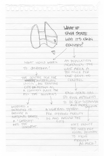
After some more thought on our concept to support our idea of enhancing Canberra, not moving the capital, Claire came up with the idea of transforming each state of Australia into a country, and creating one common Ausrtalian union in Canberra. This was developed from the original thought of politicians constantly moving around Australia in an un-sustainable way. If each state was a country and had its own resources and governments to rely on, would it reduce the travelling of politicians? This is similar to the way Europe is run, and would allow each country to be more sustainable and self-sufficient. The concept would also help to enhance Canberra, as it would become more densified and act as a 'gateway' into the continent, and may even reduce the amount of migration for people between countries as well as politicians. This concept will create more of an argument for the light rail proposal within Canberra to justify why it is viable to build this new form of infrastructure in the city. This was the thought process for Claire when developing this idea, as well as our new panel layout...


We have decided to split up the work of the project so each person does one panel. This will be the easiest way as then we can bring it together over the next couple of days and make adjustments where needed as a group. At this stage, Claire will do the first panel, I will do the second and Dee will do the third. So now we really have to get moving and get this concept on paper as the exhibition is fast approaching!

Saturday, 27 August 2011

Diagramming Examples...

During class on friday, Jane showed us some archigram work of collages which is is the kind of diagramming that is expected of us for our project. She also urged us to look on the InfraNet Lab website which has good examples of diagramming as well as some interesting concepts of design. I finally had a chance to have a thorough look at the website and found heaps of examples that would be well suited to our project- for inspiration of course! The main project below features photos, 3d views, exploded views and maps:


This is another example that uses exploded views to create layering which I think will be useful in our project:


Future Possibilities...

Claire found a website called forums for the future- megacities on the move
(http://www.forumforthefuture.org/project/megacities-move/overview)%20that) that made little videos of future scenarios. They are just cartoons but are quite interesting to get insight and ideas of crazy ways we are heading for the future. Some of the scenarios are quite scary but believable which is why I think it’s important to keep our options open for anything. For example, a total ban on cars could be possible which is why a new train network would be a good investment for the future. This leaves options open to be completely virtually run or possibly running on different resources in the future- adaptable to changing conditions.
These were the main points for each one.
1) Planned-opolis: robots, mega computer in charge of the whole city, electric bikes, car parks used to grow food, a total ban on cars in central areas.
2) Sprawl-ville: virtual jobs for teaching, students learning online-no school, many jobs non-existent- entrepreneurs bought out all government jobs, people feel powerless.
3) Renew-abad: Virtual dinners with family overseas, computer controlled vehicles- integrated transport, service jobs are more valuable, hydro pods used for cars.
4) Communi-city: no one uses public transport- money has been put into other things, everyone drives, grows biofuel in own yard.

I also found an article that reflected on these issues that had some good points about what is needed for the future, with the main factors discussing transportation methods and the need to integrate these. This is a major task so as long as we are starting to think about smaller things we can do now to cater for the future (like a sustainable light rail network=less cars on the road) then we are on the right track!

"Go beyond the car.
Current growth rates in car ownership are simply unsustainable. We need alternative ways of getting around, and new business models which encourage on-demand access to cars rather than simply ownership. We need urban planning mandates that prevent further sprawl, make it easy to walk around local communities, and provide access to key goods and services.

Integrate, integrate, integrate.
Energy, transport, business, public services and food supply can no longer be considered in isolation. We need to create integrated mobility systems that will provide people with choice, flexibility and seamless connectivity - whether they are travelling from one place to another or accessing goods and services in all sorts of different ways.

Change people's behavior.
Many of our future challenges are shaped by people's values, behavior and preferences. We need to think about ways to influence these social norms in positive ways to promote low-carbon, healthier lifestyles. The leading mobility players of the future will plan today to influence lifestyles, rather than simply relying on putting more cars on the road or developing additional road infrastructure.

None of this is science fiction. In each of these six areas, we can already see the green shoots of 'sustainable mobility' breaking through in cities all around the world. One way or another, it's going to be an exciting ride!"


http://www.nissan-global.com/EN/TECHNOLOGY/MAGAZINE/5guestsfuture-2.html

New York High Line...

I love this idea of creating an elevated park and walk way from the unused train line. The positioning of the track throughout different blocks gives the impression of it weaving its way around the city. Small gardens/seating areas/sanctuaries could also be applied to the light rail network in different areas of the city where views are prominent to enhance the aesthetics of the new system. Before Phil's lecture last week on the High Line in New York I had no idea it even existed. I enjoyed his lecture thoroughly and also gained a few more ideas which have helped to explain the project concept. I loved the idea of the breathing, eating, making, moving, dwelling concepts. As nice as it would be to try to combat all of the issues in our project and create one mega proposal for the future, it obviously would be a massive job. It is also hard though to just focus on one smaller issue because everything connects and links someway or another and a full integrated system will be the way of the future.  


Existing Infrastructure Investigation...

During the tutorial we had a look to see if there were any train lines around the area. We found that there is a country link that connects to Sydney, but the station is in Kingston and doesn't connect to the centre, so you would still have to jump on a bus to get anywhere. The train ride is about 5 hours alone from Sydney, so this would make it very hard for people to want to come for a weekend or a holiday when it is such a hassle to get there.

http://www.countrylink.info/timetables/southern/canberra_to_sydney

We also had a look where the airport terminal was, and found that this was quite far out as well (Pialligo) so we would need to make the light rail connect to the terminal to make the whole journey as easy as possible for visitors. We found that there is a new terminal being built as well so a new connection into the city is vital in creating a gateway into the capital.

http://www.canberraairport.com.au/air_newTerminal/webcam.cfm

I was interested to find proposed future links for the area and the first one that came to mind was the High Speed rail I have been hearing so much about lately. I did some research and found that there is a proposal to connect it to Canberra, which would be very beneficial for the capital. The light rail could remain open to connections like these and allow it to continue to provide mobility in the future.

http://www.infrastructure.gov.au/rail/trains/high_speed/index.aspx

WEEK 5 TUTORIAL...

Week 2 of the theme group tutorial was pretty successful as we solidified our concept of the light rail system to create a more mobile Canberra. The rail system will allow the whole of the city to connect effectively in a cheaper, energy efficient way. I think this is a more suitable form of public transport for the city than the bus’s used now with the main focus on the bicycles and walking, which not everyone can and wants to do. There is also the fact that because the city is so spread out, it is unrealistic to be able to walk and ride everywhere anyway. It would reduce car use as the rail is cheap and easy and connect from outer suburbs into the main centre. By creating a new system which will build on the existing infrastructure and connect to important links like the airport and country rail link to Sydney (as well as having the possibility to connect to future transport links), Canberra will be a lot more accessible for everybody and bring people into the area. This includes tourists coming into the area for a holiday or day trip (they can jump straight on the light rail after the country link or airport and check out all the major tourist attractions in Canberra), people who already live in Canberra (use it for going to and from work and getting around the city), politicians (use it to travel from the airport to parliament house and back again easily), and politicians and school kids who have come to Canberra to visit or stay for a long period of time (use the light rail to travel direct from accommodation to the parliamentary services rather than long bus trips or expensive hire cars).
The rail link should bring people into the area as it will be a lot easier and cheaper to get around Canberra once you get there, as well as easier to fly and train direct from Sydney as the new network will connect directly to these. This is along with the idea that in the future, major bus stops and park and ride/train will also be positioned at the train stops to create a fully integrated transport network. Around each main terminal could be developed into TOD’s- transit orientated developments in the future. Instead of more development continuing further out of the centre, there needs to be more development within the civic, and this should occur naturally with the increased amount of people at the main light rail stops. These areas could include mixed use developments (commercial, retail and eateries) which are pedestrian friendly and add to the appeal of the light rail. This would allow not so much an over developed centre in the future, but more built up hubs scattered throughout the city. This will also allow the parliament to be a social part of the community instead of being totally segregated from the city in the future where only politicians go. These main stations of the elevated light rail could potentially feature smaller break off points to sit and relax and look over significant parts of the city. This could be something like the High Line in New York.
After presenting our basic panel layout for the presentation, Jane gave us some other pointers to help enhance our concept. She mentioned that a lot of areas in Canberra are almost out of proportion because of the large scale of the main streets and the minimal numbers of people using the spaces. So, the light rail concept will help to fill these mass spaces and add something new to look at and hopefully it will be seen in the future as an important cultural component of Canberra. She also said that from a lot of areas in the civic, the views of parliament hill are naturally and intentionally framed, so we have to be careful not to totally block out all views from the elevated light rail network. These are all aspects we will have to consider in the actual design of the network but for now we have to get started on the big picture!
MAIN POINTS- WHY INTRODUCE A LIGHT RAIL NETWORK?
·        Provide easier ACCESSIBILITY to Canberra from Sydney and Melbourne to BRING PEOPLE  IN to the capital.
·        Provide easier and cheaper accessibility within Canberra to make it more MOBILE.
·        Promote CONNECTIVITY to make it easier for people coming to Canberra solely for PARLIAMENT reasons.
·        ENHANCE the cultural aspect of Canberra so it’s not only seen as a parliamentary hub but also show off all Canberra has to offer, and give Canberra a new IDENTITY.
 The following is a basic sketch of our panel breakdown draft:


Thursday, 25 August 2011

Canberra's Public Transport...

After looking into current public transport systems in Canberra, as well as future plans and strategies, I found that both Canberra and the whole ACT focus heavily on buses and not trains, which I found to be quite odd. Train systems, whether heavy or light rail are successful in major cities as well as remote areas so Canberra would benefit greatly from an additional public transport system to help in the reduction of car use. Although Canberra promotes walking and cycling in their city, it is very spread out and impossible to ride or walk to all parts of the city. In the chart below the rise in public transport is also much greater than walking or cycling, and with a lot of the demographic consitsing of an older society, a train system would be the most accessible to use.

"Transport for Canberra is a new policy and action plan for the ACT that aims to reduce the overall cost of the transport system while maintaining high levels of accessibility. Providing convenient alternatives to private cars will shift transport patterns towards more use of walking, cycling and public transport. This in turn will:
·        reduce traffic congestion
·        provide health benefits such as reduced road accidents
·        provide environmental benefits such as reduced air pollution
·        provide the community with more transport options, and
·        reduce the cost of building and maintaining transport infrastructure."


MODE
2001
2011
2026
Walking
4.1%
6%
7%
Cycling
2.3%
5%
7%
Public Transport
6.7%
9%
16%
Total
13.1
20%
30%


The following is a a very useful link to the ACT'S Accessible public transport plan:

Wednesday, 24 August 2011

Canberra Spatial Plan...

I thought this information (taken from the Canberra Spatial Plan website) was interesting as it talks about a new structure for Canberra due to an expected population of 400000 by 2032. There is also a prediction for an ageing population which causes a number of factors like infrastructure, housing, transport to consider for the future, and are possible avenues that we could consider for our project. It was helpful to analyse the maps o future and current zoning and transport links for the ACT. One main link was the high speed rail through the north south axis of the ACT to connect both Melbourne and Sydney. This could potentially also connect to a light rail system concept in Canberra and provide direct access from other areas. After some more research though it was found that there is a country link that connects Sydney to Canberra, but the end of the rail line doesn't finish near the airport or centre of town. This means that you would then have to get a bus or rental car to get into the city centre or parliament hill, which is why another form of transport like the light rail system would effectively be able to continue this journey.  The graph below shows the predicted population increase. As you can see there is only a estimated 50, 000 people increase within the next 20 years which isnt a whole lot. This is why a new network system could potentially bring people into the area more easily and create a more sustainale, populatd and compact centre.


IMPLICATIONS OF POPULATION GROWTH= NEW STRUCTURE FOR CANBERRA

http://apps.actpla.act.gov.au/spatialplan/1_future/1C_new_structure/index.htm
"The 1967 Y-Plan which has remained as the key strategic plan until now, provided for Canberra to grow through the creation of separate districts in the form of a ‘Y’.


The Canberra Spatial Plan departs from the Y-Plan in key areas by seeking to provide a more sustainable and compact city form. However, it does not resile from the multicentred model of the Y-Plan, nor ‘undo’ it.


In developing The Canberra Spatial Plan, consideration was given to areas that were capable of urban development within the ACT (Map 3 – Urban Capable Land). These areas were identified through examination of factors that may constrain, or potentially limit, the location of future urban development, including social, physical and environmental constraints. Generally these are areas currently undeveloped for urban purposes but excluding conservation areas, river corridors, habitats for endangered species and areas of steeply sloping land (20% or more). Sustainability principles were applied to determine suitability of this land for urban settlement (Map 4 – Urban Suitable Land). Key issues included maximising access to and use of existing services and facilities and infrastructure, minimising the need for new transport links and travel times, maintaining the sense of place of the city, protecting biodiversity, ensuring fiscal responsibility for the Territory and supporting employment opportunities."


The following is a link to the ACT'S government infrastructure plan for 2010, which is also very useful-
http://www.cmd.act.gov.au/__data/assets/pdf_file/0019/133165/act-govt-infrastructure-plan.pdf

National Identity...

The following was taken from the Canberra Spatial Plan and is just one of the many stratgies created for Canberra's future. I though this one, National Capital significance, best related to our concept and may be of use to us. The point I found quite interesting was intentions to "Create a clear sense of arrival into the Territory from the major approach routes including the gateway through Majura Road". I think this is an important idea as Canberra is the national capital so some kind of grand entrance is needed. The main road that connects the airport to the city moves through a country town, and the feeling of entering the 'national capital' wouldnt be very grand at all. Sure you can see capital hill from most areas, and probably get a sense of being in the parliamentary capital, but what about some kind of structure/building/landscape that really gave you a sense of arrival and excitement. Could this even be integrated into a light rail terminal that started at the airport so tourists had an easy option of jumping straight onto the light rail system for a scenic tour of Canberra? Would this create a strong sense of identity to people arriving both domestically and internationally and create a different feeling to arriving in Sydney or Melbourne? The outcomes for the plan were to keep the unique national capital elements protected while enabling growth and change, allow the bush capital image to be preserved, make sure the ‘garden city’ principles are retained, and that the hills, ridges and gullies are protected as part of the landscape setting of Canberra. I think these are all important aspects to think of when proposing any changes to Canberra, and I think we should take the viewpoint that Canberra is an 'exemplar' city for the rest of the country as it is the capital. It should be the main priority to allow it to remain 'the garden city', as the is the only city in Australia that is unique in this way, so we should be celebrating and enhancing it to show this off as best as possible.
NATIONAL IDENTITY
"As the national capital, Canberra is the symbolic heart of Australia. It represents Australian society, culture and diversity, and the attitudes of the nation. The buildings and physical elements of the city are important to the character of the national capital, as is the significance of the city in the hearts and minds of all Australians. The landscape setting of the ACT has also been a central element of Canberra’s planning policy, establishing Canberra’s image as the ‘bush capital’ and as a garden city.
Policy response
  • Preserve landscape features that give the national capital its character and setting.
  • Key elements of Walter Burley Griffin’s formally adopted plan for Canberra will be respected and reinforced within the proposed urban settlement pattern.
  • Approaches and backdrops to the city and its national institutions (shown on Map 10 — Areas of National Capital Significance) will be enhanced and strengthened. The Central National Area as defined by the National Capital Plan will be enhanced and strengthened with life brought into the area by allowing housing in areas where office employment occurs.
  • Open space between urban areas will be conserved as visual separation buffers as indicated in the landscape setting.
  • Areas that are identified as the rural setting surrounding the city will be retained.
  • Key vistas will be retained within new settlement areas.
  • The ‘garden city’ principles will be retained, with urban open space within districts protected.
Actions
  • Preserve the Territory’s bush capital image by continuing to protect hills, ridges and gullies, watercourses and major water features (including the urban lakes) from urban development through the National Capital Plan and the Territory Plan. All areas indicated as landscape setting and rural setting in the Spatial Plan will be appropriately protected through amendments to the National Capital Plan and variations to the Territory Plan.
  • Working with the National Capital Authority, the Territory will limit any undesirable effects of urban growth and change on key elements of the national capital and of Walter Burley Griffin’s plan.
  • Working with the National Capital Authority, the Territory will identify any required amendments to the National Capital Plan to allow mixed land uses in the Central National Area so that residential development can occur in appropriate locations adjacent to, and within, major employment areas.
·      Create a clear sense of arrival into the Territory from the major approach routes, including the gateway through Majura Road. Clear entry statements will be established (the treatment of which will need to be determined). The city’s approach routes will be protected, including those outside the ACT borders, as far as possible from inappropriate ad hoc development by providing enough development opportunities in more appropriate locations to satisfy market demand and through agreements with NSW State and Local Governments."
 

Canberra Parklands...


After our team’s initial meeting and our decision to create strategies that enhance Canberra rather than totally shift or change it, I have been trying to think of ways to do this, which is harder than I thought. My first thought was the light rail concept to improve accessibility around Canberra and make it a more liveable area. I still think could be an interesting avenue to explore, but what else can we do to enhance Canberra’s parliament and make people want to go there? To help gain insight into Canberra’s strategies at the moment, future plans and general things to do in the area, and to trigger any possible ideas, I started to do more research of all kinds of issue in Canberra as well as the ACT.

Canberra parklands are a big part of the city being the main public space used in the area as it sits between the parliament hill and the centre of the city. I don’t know just yet how this directly relates to what we can propose to enhance the city, but it is something that needs to be considered as it seems to act as almost like the heart of the city, and something that needs to be cherished. If we do go ahead with the light rail idea, the parklands could almost be incorporated into the light rail network itself. Maybe there could be urban spaces in parts of the rail network that overlook areas of Canberra, like the parklands. If we use an elevated system, then views could be created over different parts of the parklands, as well as other significant parts of the city. The following is information speaks of the parklands as well as the design competition that was held a couple of years ago to create an area that met the requirement of the brief, listed below.


CANBERRA PARKLANDS
https://peacekeeping.nationalcapital.gov.au/overview.asp

"The Canberra Central Parklands are nationally significant because of their place in the Griffin Plan and for the blending of commemorative and natural locations. The Parklands are also locally significant as the largest and most heavily used, open spaces in the city.
Spanning 115 hectares, the parklands are bounded by the northern shore of Lake Burley Griffin, Parkes Way, and Commonwealth and Kings Avenues. The area includes the existing open spaces of Commonwealth Park, Kings Park, Rond Terraces and Aspen Island. The parklands include Regatta Point, the National Capital Exhibition, the National Carillon, Blundells' Cottage and the section of lake shore gazetted as RG Menzies Walk.
Commonwealth Park
At the western end is Commonwealth Park, a complex of mature gardens and park areas, exotic and native trees and shrubs and extensive areas of irrigated grass. This park provides a range of landscape experiences and includes a series of water features, a carpark, the National Capital Exhibition building at Regatta Point, Stage 88, service and other minor buildings, shelters, play structures, sculptures and memorials and paths.

Kings Park
At the eastern end of the parklands is Kings Park. This park has a more open character, with dryland grassed areas and areas of native and exotic woodland. The park includes Blundells Cottage, several national memorials and on Aspen Island, the National Carillon. Kings Park also has roads, car parks, minor structures and paths.

Rond Terraces
In between these parks are the Rond Terraces, a series of grassed terraces descending from a car park to the lake. These terraces visually extend Anzac Parade and Griffin's Land Axis down to the lake."